Building a better forecast in ‘Blizzard Alley’
UND Atmospheric Scientist Aaron Kennedy seeks answers to the chilling mysteries of winter storms
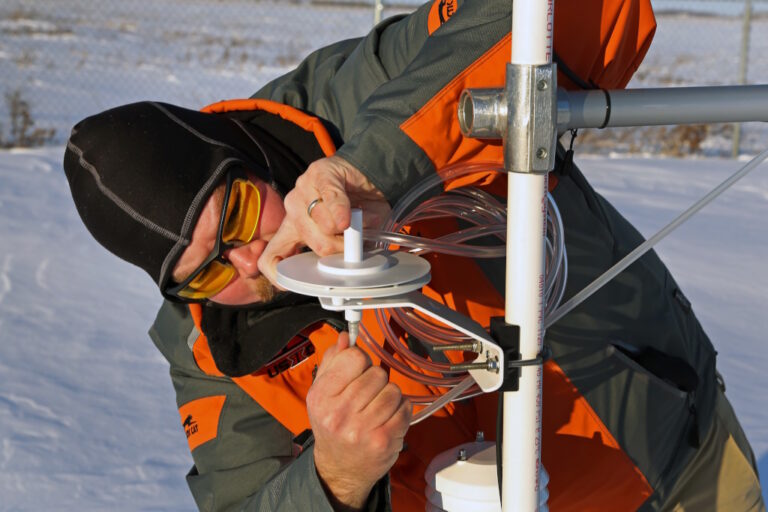
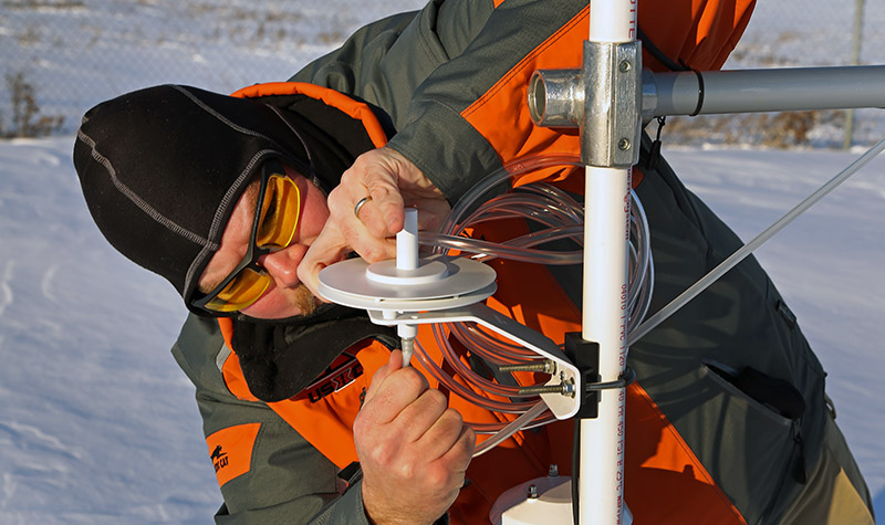 Aaron Kennedy, UND associate professor of atmospheric sciences, braves subzero temperatures to perform maintenance on weather instruments at the Oakville Field Station west of Grand Forks, N.D. Photo by Patrick C. Miller/UND Today.
It’s that time of year on the Northern Plains when weather forecasters predict winter storms and the public turns a critical eye toward the accuracy of the forecasts.
Did it snow more or less than predicted? Was it windier or less windy than forecast? Were travel conditions better or worse than expected?
“I tell my students to be thankful for being a meteorologist or climatologist because there’s no way around it: weather and climate impact people,” said Aaron Kennedy, associate professor of atmospheric sciences at the University of North Dakota. “I think everyone who lives in the region has probably experienced a blizzard and has a story about how the forecast got it wrong. I want to figure out why we’re wrong sometimes and how we can improve future forecasts.”

Aaron Kennedy
To help find these answers, Kennedy conducts research on winter weather and climate. His work is funded by the North Dakota EPSCoR (Established Program to Stimulate Competitive Research) and the National Science Foundation (NSF), among other organizations and agencies. He is the co-lead for EPSCoR’s Center for Regional Climate Studies (CRCS) with Jianglong Zhang, UND associate professor in atmospheric sciences.
North Dakota benefits
Through CRCS, Kennedy and other researchers around North Dakota study how global climate impacts regional weather, extreme weather events and agricultural productivity. Computer modeling and simulations help scientists understand how global climate impacts North Dakota agriculture in the areas of field hydrology, general land use, biomass production and human behavior.
Kennedy collaborates with the National Weather Service (NWS) office in Grand Forks, just west of the UND campus, where a number of the University’s atmospheric science graduates work.
“Through EPSCoR, we partnered with the weather service to publish a climatology of blizzards,” he explained. “We formally documented when blizzards occur and the type of patterns they have, and we demonstrated how we could use basic computer algorithms to separate different types of patterns. The problem is that we have minimal data to actually validate whether the models are performing correctly.”

As part of his research on winter storms, Kennedy takes photos of snowflakes to show how their formation impacts snowfall totals. Photo courtesy of Aaron Kennedy/UND Atmospheric Sciences.
When it comes to modeling and simulating winter storms, Kennedy believes there are many questions CRCS researchers can help answer. For example, the effects of blowing snow aren’t factored into the models used to simulate winter storms, he said.
“The amount of work being done with high-resolution weather modeling in winter is minimal,” he said. “That’s really a frontier that hasn’t been investigated. We don’t have a true understanding of how well these models simulate the wintertime environment.
“It’s a very challenging environment because in the lowest layer of the atmosphere where blizzards occur – the boundary layer – there are very few observations about what’s happening,”
Where’s the blizzard?
This is primarily because the curvature of the earth limits weather radar from seeing conditions at the surface the further away those conditions are from the radar antenna. Kennedy has satellite photos and images taken from the SkyCam high atop UND’s Clifford Hall showing ground blizzard conditions in the Thief River Falls, Minn., area that weren’t visible on the NWS weather radar in Mayville, N.D.
“We had part of the Red River Valley with no blowing snow and another part with blizzard conditions,” he said. “I looked at some of the model output for that day. None of the models had the right answer. They don’t include the process of blowing snow. Even the wind field didn’t match what was observed. We’ve got our work cut out for us.”

Photos from the UND SkyCam taken in February 2019 show a ground blizzard near the Grand Forks, N.D., area that wasn’t visible on weather radar. Photo courtesy of Aaron Kennedy/UND Atmospheric Sciences.
Kennedy is studying such factors as how blowing snow impacts the weather, how the ability to forecast ground blizzards can be improved, how winter storms can be modeled more accurately, how snowflake structure affects snowfall amounts, how land use impacts the weather and how temperature and precipitation trends are changing.
For those who study extreme winter weather events, Kennedy said there’s no place like the Red River Valley in eastern North Dakota and western Minnesota.
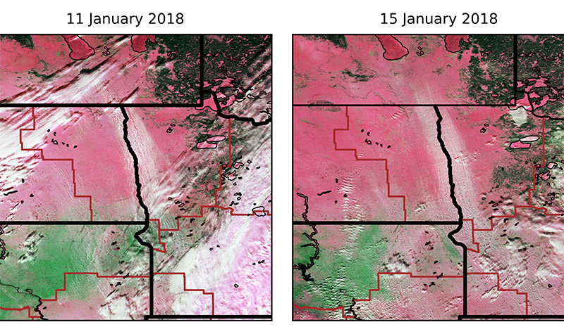
This satellite image from January 2018 shows blizzards occurring in the Red River Valley between North Dakota and Minnesota. Photo courtesy of Aaron Kennedy/UND Atmospheric Sciences.
“If we look at all the reported blizzard events in the contiguous 48 states, the Red River Valley is the peak in the nation for non-mountainous areas,” he explained. “It’s a combination of factors. One is that we get a variety of systems that cause blizzards. We get big Colorado low-pressure events, and we get Alberta Clipper systems that come out of Canada. We also get systems that are somewhere in between.
“In addition, land cover with a lack of trees promotes strong winds.”
Looking ahead
This is important in forecasting North Dakota’s weather and long-term climate trends because the state’s precipitation events are driven by large-scale weather patterns, according to Kennedy.
“One of the biggest debates in the scientific community right now is whether these large-scale weather patterns are changing,” he said. “What people should focus on is how often the temperature is above or below average, because if that’s changing, it becomes the actual climate trend.
“In North Dakota, for example, the probability of us setting a record low temperature has gone down, at least during the wintertime. We’ve seen a slight increase in days where the temperature is above freezing in the middle of winter.”

Through North Dakota, EPSCoR and the Center for Regional Climate Studies, Kennedy and other researchers around the state study weather and climate trends. Photo by Patrick C. Miller/UND Today.
Kennedy also noted CRCS research through EPSCoR showing that maximum summertime temperatures in North Dakota aren’t going up as much as expected.
“The climate models show us getting warmer in the summer than we’re actually getting,” he explained. “This could be because the models don’t adequately consider the land surface in an area dominated by agriculture. We’ve seen a transition from grains to soy beans and corn. Those plants are much more effective at moving water back and forth between the atmosphere and the land surface.”
Kennedy said that through EPSCoR, proposals are being submitted for more collaborative research with entities such as the National Oceanic and Atmospheric Administration (NOAA). He sees that work leading to the creation of apps the public can use for better forecasts of ground blizzards and other severe weather events.
“There’s always going to be some uncertainty in forecasting weather,” Kennedy noted. “Conveying the uncertainty is where most of our progress needs to be made. This information will hopefully help people make better decisions.”