A weather eye over GrandSKY
In partnership with GrandSKY, UND researchers use specialized drone to gauge weather, improve forecasting
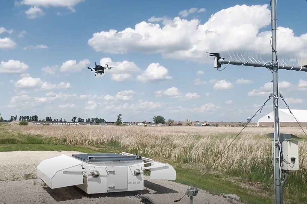
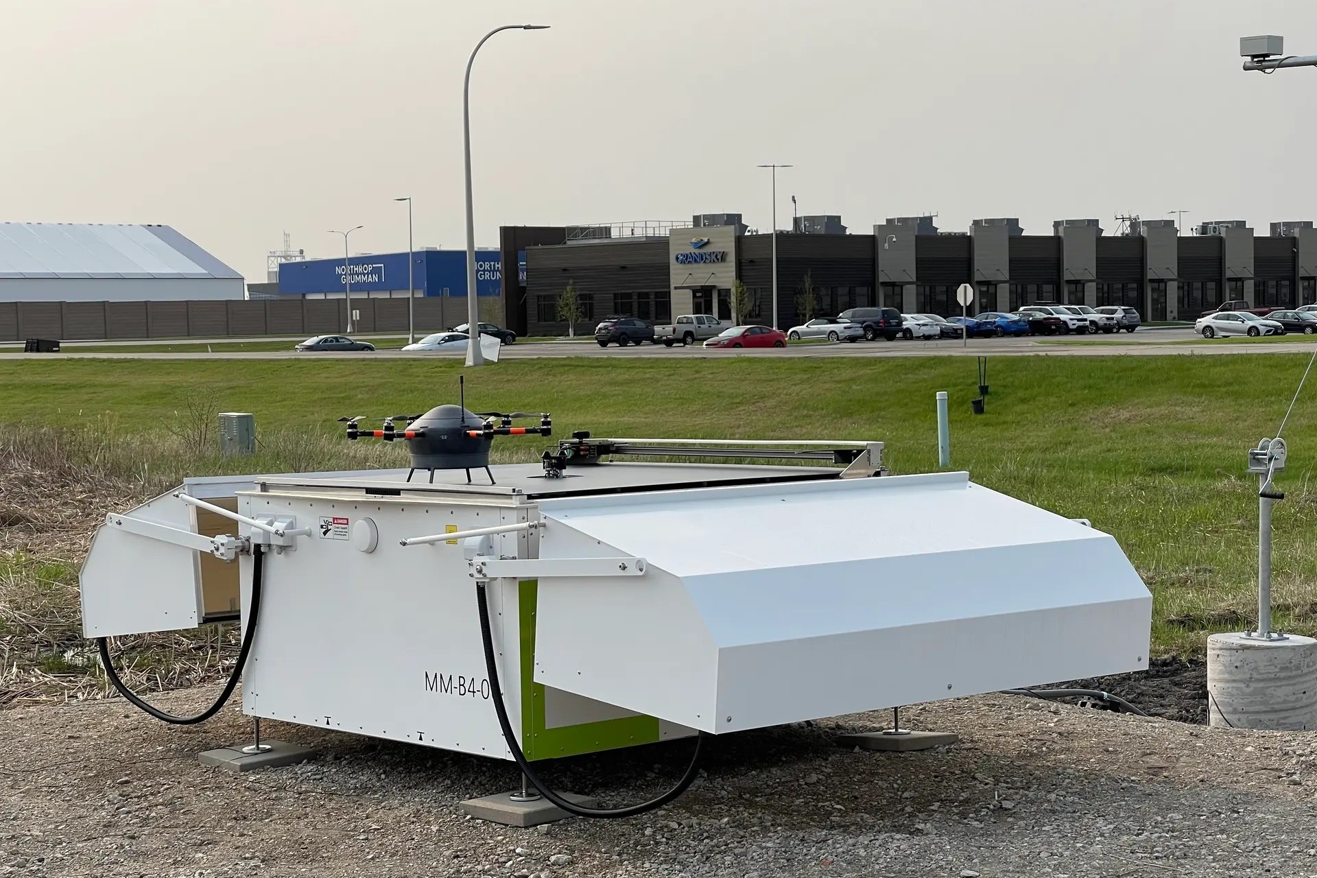
A research team from the University of North Dakota Department of Atmospheric Sciences recently participated in an intensive field campaign at GrandSKY, the nation’s first commercial uncrewed aircraft systems aviation park, to conduct weather sensing using the Meteodrone.
This collaboration between UND and GrandSKY consolidates UND’s partnership with GrandSKY and represents a major step forward in the integration of drone-based atmospheric sensing into operational UAS environments, supporting both aviation safety and scientific advancement.
Strategically located on the Grand Forks Air Force Base in North Dakota, GrandSKY is the first and only fully operational commercial unmanned aerial systems research and development park in the United States.
The UND team was led by Mounir Chrit, assistant research professor and principal investigator, alongside Marwa Majdi, assistant research professor and co-investigator. The campaign also included Claiborne Wooton, a graduate student who’s working on both the scientific and operational dimensions of the project.
The campaign’s objective was to test, in real-world conditions, how weather data can be effectively collected and operationalized using drone-based systems. The effort also aimed to evaluate how technologies developed at UND can be integrated into GrandSKY’s decision-making environment to support advanced airspace operations.
Throughout the demonstration, the team successfully demonstrated data acquisition workflows, coordination with GrandSKY operations and potential pathways for system integration.
The data collection was conducted near sensitive and dynamic airspace, including the Grand Forks International Airport, Grand Forks Air Force Base and several aerospace and defense companies headquartered at or near the GrandSKY facility. The team worked closely with Aaron Sykes, flight ops project manager and lead pilot at GrandSKY, as well as local air traffic control to ensure compliance with FAA and Department of Defense regulations governing UAS operations.
Operating within this ecosystem required strict adherence to UAS navigation constraints, including coordination with air traffic control, altitude restrictions and real-time deconfliction with crewed and uncrewed flights. This environment offered a realistic setting for assessing how such sensing operations might scale in both civilian and military contexts.
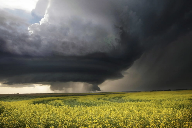
The team also discussed how to optimize the use of the Meteodrone for both efficiency and cost-effectiveness. A product of Meteomatics, a Switzerland-based firm, Meteodrones are weather drones that are specifically engineered for meteorological purposes. They operate “within the Earth’s lowest atmospheric layer, known as the boundary layer, and are equipped with sensors for weather data collection, gathering key atmospheric data such as temperature, humidity and wind conditions,” the Meteomatics web site reports.
The information collected by these drones is instrumental in enhancing the accuracy of weather forecast models, providing a more comprehensive understanding of atmospheric dynamics.
This collaborative effort represents an important step toward bridging university-developed environmental sensing and modeling technologies with the operational needs of commercial and defense aviation environments.
In addition, the project is delivering significant educational benefits by providing students with hands-on experience in applied atmospheric science. Through direct involvement in flight operations, data collection and collaborative fieldwork, students are gaining practical skills that go beyond the classroom, ranging from mission planning and drone deployment to data assimilation and model calibration and validation.
Participating in this type of real-world campaign strengthens technical competencies, fosters interdisciplinary thinking and prepares students for future careers in environmental research, aviation meteorology and operational forecasting.
Further analysis and results will inform future deployments and collaborative frameworks between UND, GrandSKY and other airspace innovation stakeholders.
This collaborative initiative, grounded in science and guided by operational need, exemplifies how universities, students and industry can partner to shape the future of safe, sustainable and cost-effective drone integration into the National Airspace System.